ABSTRACT (state 2006):
- The "Crater of Pantasma" in Nicaragua has not yet been noticed by the science.
- A volcanic origin is suggesting but not proven (is there any unpublished evidence?).
- Without the volcanic vicinity a meteoric origin would be evident.
- Impact material has obviously not yet been searched for.
UPDATE 23.3.2023:
- The PANTASMA Crater has finally been included in the "Earth Impact Database", the world's database of recognized meteorite impacts (almost 17 years after my initial discovery and 4 years after the scientific proof by Pierre Rochette e.a.). This means that PANTASMA is "officially" recognized as the largest impact crater in the last million years. PANTASMA is also one of only 5 impacts, that can be assigned to a tektite strewn field (Belize/Tikal). PANTASMA is undoubtedly the most spectacular discovery of meteorite craters in recent years. PANTASMA is the first known impact crater in Central America and is listed as 13th in the South American section of the Earth Impact Database (54th Lunar and Planetary Science Conference 11.-17.3.2023).
UPDATE 11.2.2019:
- Pantasma: Evidence for a [about 815.000 years old] Pleistocene circa 14 km diameter impact crater in Nicaragua
by Pierre Rochette, R. Alaç, P. Beck, G. Brocard, A. J. Cavosie, V. Debaille, B. Devouard, F. Jourdan, B. Mougel, F. Moustard, F. Moynier, S. Nomade, G. R. Osinski, B. Reynard and Jean H. Cornec
(https://onlinelibrary.wiley.com/doi/full/10.1111/maps.13244):
ABSTACT "
The circa 14 km diameter Pantasma circular structure in Oligocene [23-34 million years old] volcanic rocks in Nicaragua is here studied for the first time to understand its origin. Geomorphology, field mapping, and petrographic and geochemical investigations all are consistent with an impact origin for the Pantasma structure. Observations supporting an impact origin include outward-dipping volcanic flows, the presence of former melt-bearing polymict breccia, impact glass (with lechatelierite and low H2O, < 300 ppm), and also a possible ejecta layer containing Paleozoic rocks which originated from hundreds of meters below the surface. Diagnostic evidence for impact is provided by detection in impact glass of the former presence of reidite in granular zircon as well as coesite, and extraterrestrial ε54Cr value in polymict breccia. Two 40Ar/39Ar plateau ages with a combined weighted mean age of 815 +/- 11 ka (2 σ; P = 0.17) were obtained on impact glass. This age is consistent with geomorphological data and erosion modeling, which all suggest a rather young crater. Pantasma is only the fourth exposed crater > 10 km found in the Americas south of N30 latitude, and provides further evidence that a significant number of impact craters may remain to be discovered in Central and South America."
UPDATE 2017:
- Geological investigations in Pantasma by Pierre Rochette of the University of Marseille/Aix-en-Provence in Feb. 2016 show evidence of the impact origin: "...show that these glasses are of impact origin..."!
UPDATE 2010:
- The Geologist Jean H. Cornec from Denver (Colorado, USA) has found 800.000 year old Tektites in Belize, 500 km north-west!
UPDATE 2009:
- An expedition in July 2009 by the Nicaraguan Astronomic Associaton(ASTRONIC) has confirmed the impact-theory:
"A METEORITE FORMED PANTASMA?
An expedition in July by the Nicaraguan Scientific Association of Astronomers and Astrophysicists (ASTRONIC) to the Pantasma Valley in Nicaragua's northern department of Jinotega determined that this circular valley, with a diameter of over 12 kilometers, was formed by the fall of a meteorite long ago, as shown by the composition of the rocks studied at the edge and in the center, where the impact occurred. A more specific study of the meteorite's composition is in its first stages.
Two years ago, while 'traveling' on Google Earth a German named Leo Kowald found a hollow in the Pantasma area that he suspected to be formed by the impact of a meteorite. Prior to the expedition, David Castillo Pacheco, Astronic's president, had commented that the hollow was outside Nicaragua's volcanic mountain range, thus discarding the possibility of it being the relic of a (volcanic) crater..."
Written in April 2006:
Nicaragua, a country with about 6 million inhabitants, lies in the middle of the central American land bridge and is part of the
geologically young
Caribbean plate, which was formed about
140 to 70 million years b.C., when the plates of South- and Northamerica moved together. [Note: For this reason the Pantasma valley can not be "triassic", 255 to 200 million years ago] In the west, near the Pacific coast line there is active volcanism in form of
a chain of volcanoes, calderas and lagoons, which is caused by the subduction of the Pacific sea floor under the
Caribbean plate. In this zone there are often violent earthquakes, by which on
12/23/1972 the capital Managua was nearly completely destroyed. The eastern part of the country drops slightly to the Atlantic Ocean. The central and northern part take mountains with up to over 2000 m high summits, which were created in the Tertiary (chronologically after the Mexican Chicxulub impact 65 million years ago) by volcanic activity. (
*1)
There, approximately 70 km south of the border to Honduras, in the district of
Jinotega, you can find that circular valley, the "
Valle de Pantasma". It is passed from SSW to NNE by the "Rio Pantasma", a tributary of the "Rio Coco" (also called "Rio Segovia"), with "
Las Praderas" (today "
Pantasma") in its centre which is the main village of the municipality "
Santa Maria de Pantasma"(
not to confuse with the little village 21 km south-east of Pantasma, where Google-Maps points to under "Santa Maria de Pantasma"!), with over 50,000 inhabitants (2015). In the poor, but obviously fertile and
agriculturally intensely used valley the people cultivate corn, grain, fruit and coffee and raise cattle.
Sad celebrity attained the place on October 18, 1983 by the "
Massacre of Pantasma", in which 47 men, women and children were assassinated during an assault on the agricultural cooperatives of the valley by CONTRA terrorists, who were financed and armed by the United States under president
Ronald Reagan against the Sandinist government. Exactly three years later, on October 19, 1986 an anti-
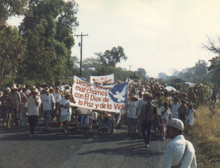
tank mine blew up a truck on the main street from Pantasma to Jinotega killing 11 and maiming 33 civilians. On Monday, March 23, 1987 Members of the US-American "First Veteran Peace Action Team", lead by the Vietnam veteran
S. Brian Willson started a one-week and 73-miles "Peace Walk" on this road passing the Pantasma Valley in order to focus public attention on the CONTRA terror, that was very cruel particularly in this part of the country. (*1)
Since 2004 the terrain is cleared from the landmines in that area and the "civil" war is definitely terminated since 1990. But prudence and the assistance of a guide are strongly recommended, if one wants to travel there.
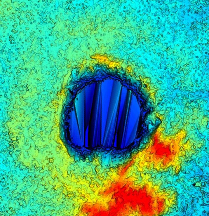
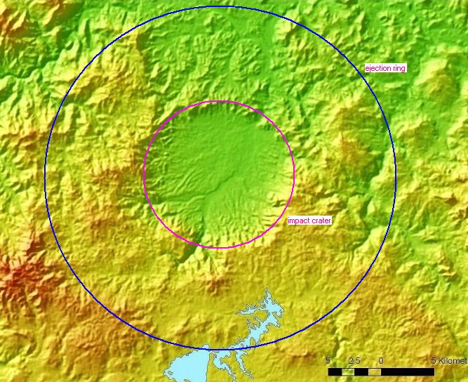
The floor of the valley rises from NNE to SSW from 400 m to over 500 m.
In front of the outlet of the Pantasma river at the northern edge a plain has been formed,
which looks like a puddle in a flat bowl, which stands on an inclined table
(see accompanying, triple super elevated Google picture). Because of the inclination, the
500 m line crosses the valley, why its circular shape is often not visible in maps.
In E, S and W the circle is somewhat bumped out,
which is obviously caused by well recognizable ravine-
like slope washings with related debris deposits
at the edge of the valley, which lie under the highest summits of the 600 m to 1100 m
high surrounding ring of mountains.
The valley interrupts the flank of an about 1000 m high mountain plateau,
which drops by some 100 m toward NE, where also the gradient of the
floor points to.
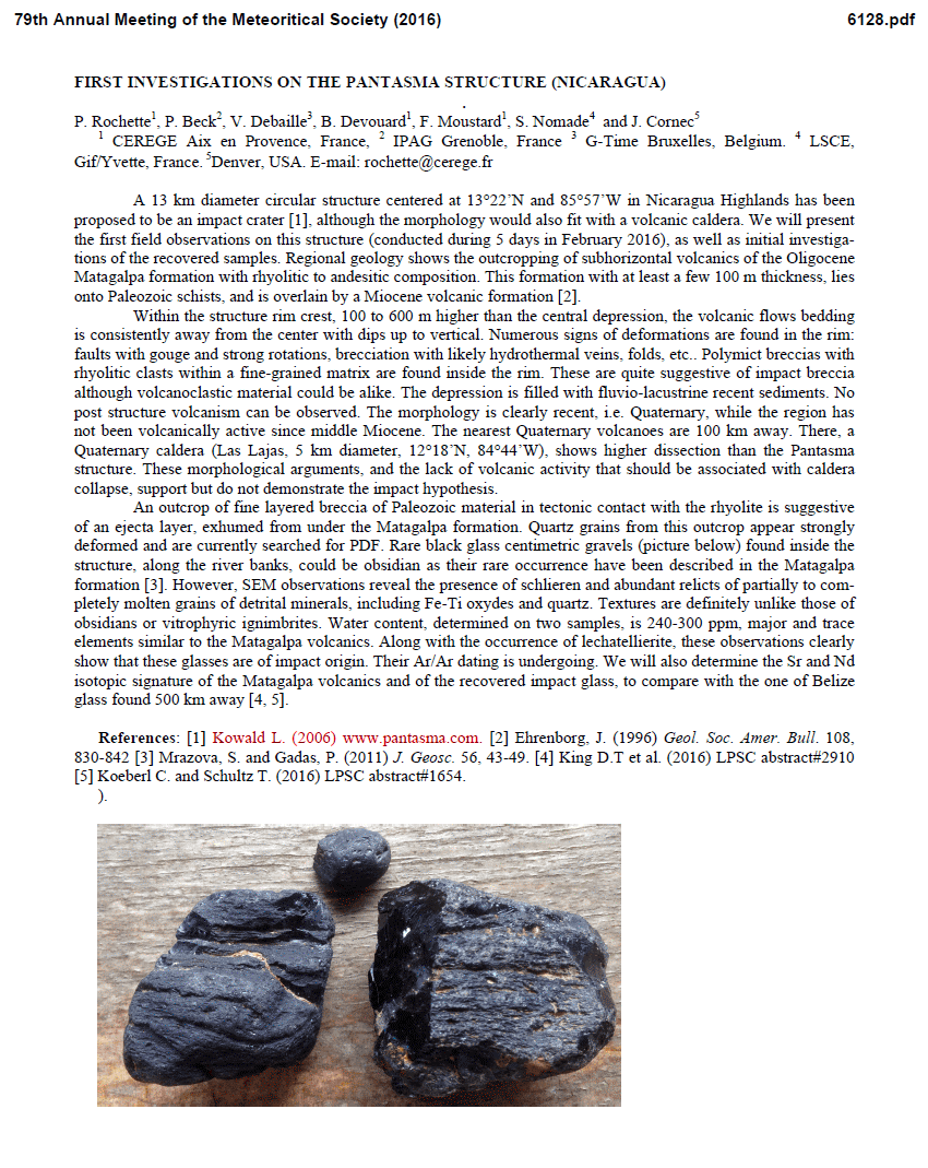
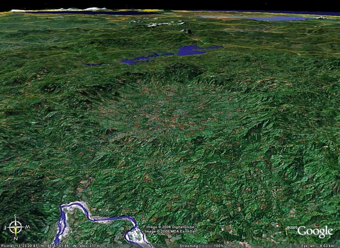
My journey through Nicaragua did not lead me into the proximity of the crater and I could look at it only by "
Google Earth", maps and this beautiful shade relief, which was kindly sent to me by Dr. Wilfried Strauch, director of the geologic institute "
INETER" (Managua, Nicaragua). On this certainly still insufficient base I believe as an amateur astronomer, who saw many pictures of volcanic and
impact craters on the moons and planets of the solar system, I find that the "Valle de Pantasma" was obviously caused by a
meteorite impact. After the rule "crater by 20" the meteorite should have had a diameter of
more than 500 m. I would even call the crater a typical sample of a meteorite impact, if the central uplift would not be missing, which is however often not present in very large impact craters (over 5 km). In this rainy area it can be covered with sediments in the meantime.
In a distance of 10 km off the crater there are some hills, that could refer to an ejection ring, that is however not clearly recognizable in that rough region. Its embedding into the landscape is nearly identical to the 5 km large and 50 million years old impact crater of
Goat Paddock in Australia. Its size and shape reminds at the 10 km large and about one million years old crater of
Lake Bosumtwi in Ghana.
The Crater of Pantasma fulfills all outer conditions of a meteorite crater. I find that, beside the circular shape, the inclination toward the spacious form of the mountain slope is remarkable. The arbitrary position of the crater in the landscape corresponds to the arbitrariness of a meteorite impact. I beleive, that its spectacularity itself already shows that it does not have to do something with the volcanic structures in that area; it is simply extraordinary. It must be substantially younger than its environment. Its narrow northern mountain-bow also doesn't look like a rim of a collapsed caldera. In my opinion this crater can only be caused by a big explosive event 1 or 2 million years ago, bigger than the explosions of Krakatoa Tambora and the Lake of Laach ( ⇒ Wikipedia: Explosive Calderas). After R. Weyl, the era of active volcanism in this region however has ended already more than 5 million years ago (tertiary volcanism). But I have to admit, that I simply don't have enough knowledge about geology to estimate the probability of a volcanic origin. (*3)
Despite intense investigations I haven't found any traces of a Crater of Pantasma or Las Praderas in the Internet. In "
The Geology of Central America" by Richard Weyl (ISBN 3-443-11001-0) the valley is not mentioned. In contrast to the 120 km more southern lain extinct volcano "
Las Lajas", which is called - despite its substantially smaller caldera of 7 km - "the largest volcano of possible Quaternary age east of the Nicaraguan graben", it doesn't appear in
relevant lists of volcanic objects. Unlike the other craters it is not part of one of the two volcano chains (the young south-
western and the elder nort-eastern of the nicaraguan graben). Also our competent Nicaraguan guide did not know anything about it. It seems to me, that the crater has not been noticed at all by the international science community so far. Only Dr. Strauch from INETER wrote me, that he already had noticed the crater, but his geologists had thought, that it is volcanic.
Although meteorites are not much concerned about the geologic properties of their target areas, the probability, that this is "only" an unusual volcanic object, is rather high. But there is no literature or at least a discussion about it, although the crater should be interesting enough even as a pretended caldera. I suppose that the Nicaraguan geologists for comprehensible reasons have much trouble
with the research and the forecast of dangerous seismic and volcanic activity, and simply not much time for less important questions.
The question "volcanic or meteoric" can be decided certainly only
by geologists by minerals
(
shatter cones,
suevites,
tektites),
that have to be found in or near the Pantasma Valley.
Therefore it would be fantastic, if a geologist went there soon to answer that question!
In the language of the Miskitos "Pantasma" means "small man" or "flat head".
The Spanish word "Fantasma" comes from the Greek "Phantasma" and means "ghost".
Should I only be fooled by a Phantasma?

Dear Visitors!
If you have questions, critics or recommendations, please do not hesitate to
send me a Mail!
Foot Notes:
*1)
The northern [Mexico, Guatemala and Belize (L.K.)] and the southern [Honduras, El Salvador, Nicaragua, Costa Rica and Panama (L.K.)] part of Central America show different construction and deviant geological history. In the north, the "Sapperland", there is a Paleozoic orogen, over which lie Mesozoic, germanotypically disturbed layers. In the south, however, stronger Cretan orogeny is suspected in Panama. It follows from the Upper Cretaceous to the development of a geosyncline, which is unfolded in the Miocene. Initialer and synorogenic magmatism are strongly developed. The course of the fold ranges deviates from previous conceptions and forms two open to the south arches. In the Tertiary, Central America is the scene of strong sialic volcanism, whose magma can not be traced back to the melting of a sunken orogen root. After a period of relative tectonic and magmatic calm in the Pliocene, quaternary liveliness prevails. The Quaternary, also predominantly sialic volcanism is bound to the fracture zone running parallel to the Pacific coast. Among the typical features of the circumpacific structures are proven: a deep-sea trench, a zone of active volcanoes and a zone of lively activity. (After a lecture "The Orogens of Central America" by Richard Weyl, held on March 14, 1960 in Würzburg at the 50th Annual Meeting of the Geological Association)
|
*2)
S. Brian Willson's Video Clip,
9 minutes (2.3MB): http://www.peace.ca/brianwillson.wmv.
S. Brian Willson,
who organized the Peace Walk, is the Vietnam veteran who lost his
legs when run over (with full intention!) by a naval train in Concord,
California, carrying weapons that were headed for Central America.
Brian is one of the most spiritual, courageous and honest
activists who Wages Peace against violent foreign policies.
He is a hero in Central America where the people understand that he has stood up for
their rights as equal human beings. Brian says that he doesn't want
Mothers and Fathers and Children to be killed and maimed in our name with our
tax money! (Singer, actor) Kris Kristofferson gives him a special
introduction. Brian's web site: http://www.brianwillson.com
features his autobiography and a series of essays he has written.
I recommend getting on his web site and reading everything he has to offer!
|
*3)
The basement of northern Nicaragua is still a great problem stratigraphically.
Enclosed tuffits (mainly basic, partly also intermediate to acid) appear of importance
for both petrology and sedimentology. Not in the least they are guide horizons for a
more accurate mapping. The vast regional distribution, commonly proved yet, suggests
that the composition of the basement is considerably uniform and it seems that they
do not belong to different periods and formations. Structurally the region is exceedingly complicated.
The folding direction as regards plication and overthrusts is mainly to the North,
but partly also to the East.
Probably the ldquoTotogalpa formationrdquo (fanglomerates, conglomerates and sandstones,
mainly reddish) which follows disconformably over the basement, already indicated, belongs
to the sequence of tertiary tuffites, agglomerates, lavas etc. as they conformably form a
formation of uniform composition. The relation of basement to lower Cretaceous
(marine Albian; ldquoMetapanrdquo), which follows immediately to the south, is less clear.
The lower Cretacious shows intensive and complicated folding at Siuna and it appears
almost unmetamorphosed (? basement in a wider sense).
The marine sediments (upper Cretacious - Miocene) of South Nicaragua are orogenetically
only slightly efected (folding direction to E-N). To the North follows a thick serie of
Tertiary and Quarternary volcanites (initially mainly submarinal, later on continental).
Together with the NW/SE lineaments (Nicaragua depression, lines of volcanoes, coast
line in the SW etc.) also NS directed ones clearly appear (coastline in the East).
This direction can be found e. g. in the ldquogranite ridge of Susucayanrdquo and the
accompanying faults in the vicinity. These latter structures may have taken an active
part in the development of the flexured border of the Nicaraguan depression NW of Managua.
("Geologische
Problematik und Strukturanalyse Nikaraguas" by Bruno Engels, 1965)
|
Sources:
54th Lunar and Planetary Science Conference 11.-17.3.2023
G. R. Osinski, R. A. F. Grieve, P. J. A. Hill, J. Newman: Impact Earth - A 2021 Update on the Terrestrial Impact Record. 52nd Lunar and Planetary Science Conference (2021)
PANTASMA in the Canadian "Impact Crater Database" (2019)
Pierre Rochette e.a.: PANTASMA: EVIDENCE FOR A PLEISTOCENE CA. 14 km DIAMETER IMPACT CRATER IN NICARAGUA - onlinelibrary.wiley.com 11.02.2019 (PDF)
Jean H. Cornec: NEW TEKTITE STREWN FIELD DISCOVERED IN WESTERN BELIZE
G. R. Osinski, R. A. F. Grieve, P. Hill, J. Newman, P. Patel, G. Tolometti: Impact Earth - New Insights into the Terrestrial Impact Record and Cratering Processes. 50th Lunar and Planetary Science Conference (2019)
J. Martell, C. Alwmark, P. Lindgren, L. Johansson: Former Reidite in Granular Neoblastic Zircon Grains (FRIGN zircon) from the Mien Impact Structure, Sweden. 50th Lunar and Planetary Science Conference (2019)
A. J. Cavosie, N. E. Timms, L. Ferrière, P. Rochette: FORMER REIDITE IN GRANULAR NEOBLASTIC ZIRCON ( FRIGN ZIRCON ) FROM THE LUIZI IMPACT STRUCTURE AND PROPOSED PANTASMA STRUCTURE. 49th Lunar and Planetary Science Conference (2018)
Pierre Rochette e.a.: FIRST INVESTIGATIONS ON THE PANTASMA STRUCTURE (NICARAGUA), 79th Annual Meeting of the Meteoritical Society (August 2016 Berlin)
D. T. King Jr., J. H. Cornec, L. W. Petruny, H. Zou: TEKTITES OF WESTERN BELIZE - CHARACTERISTICS AND POSSIBLE ORIGIN. 47th Lunar and Planetary Science Conference (2016)
V. H. Hoffmann, M. Kaliwoda, R. Hochleitner, M. Funaki, M. Torii: Investigating Possible Belize Tektites. 47th Lunar and Planetary Science Conference (2016)
H. Povenmire: Extending the Belize Tektite Strewn Field. 47th Lunar and Planetary Science Conference (2016)
Jean H. Cornec e.a.: THE 2014 REPORT ON THE BELIZE TEKTITE STREWN FIELD. 46th Lunar and Planetary Science Conference (2015)
V. H. Hoffmann, M. Funaki, J. H. Cornec, M. Kaliwoda, R. Hochleitner: MAGNETIC PROPERTIES AND MICRO RAMAN SPECTROSCOPY OF A CENTRAL AMERICAN TEKTITE FROM BELIZE. 44th Lunar and Planetary Science Conference (2013)
J. H. Cornec, L. H. Cornec, H. Povenmire: A Layered Tektite from the Central American Strewn Field. 44th Lunar and Planetary Science Conference (2013)
W. H. Schwarz, M. Trieloff, K. Bollinger, N. Gantert, V. A. Fernandes, H.-P. Meyer, H. Povenmire, E. K. Jessberger, C. Koeberl: Coeval Ages of Australasian, Western Canadian and Belize Tektites. 44th Lunar and Planetary Science Conference (2013)
Jean H. Cornec e.a.: CENTRAL AMERICAN TEKTITE STREWN FIELD UPDATE. 43nd Lunar and Planetary Science Conference (2012)
Jean H. Cornec e.a.: THE NEW CENTRAL AMERICAN TEKTITE STREWN FIELD. 42nd Lunar and Planetary Science Conference (2011)
"Había una vez, un meteorito" La Prensa (Nicaragua) 14.9.2014
"A METEORITE FORMED PANTASMA?" in Envio.Org Sept.2009, ASTRONIC Expedition Pantasma-Valley July 2009
Richard Weyl: "Die Geologie Mittelamerikas", Borntraeger, 1961 (ISBN 3-443-11001-0)
International Journal of Earth Sciences, Springer 1960 (ISSN: 1437-3254)
Bruno Engels:
"Geologische Problematik und Strukturanalyse Nikaraguas". Geologische Rundschau 54(2) 1965
"Sterne und Weltraum", Heft Mai,
Juli 2006
INETER, Managua, Nicaragua
Köberl and Sharpe: Review of impact cratering
LPI: Pantasma
Kratergrößen-Rechner
www.steinheimer-becken.de
www.mineralienatlas.de
University of Texas: Caribbean Plate Project
NSF press release 96-009
Doxler, Cunningham: An Ocean Drilling Journey, RICE University
Raik Bachmann: The Carribbean Plate and the question of its formation
Earth Impact Database
Günther Weber: "Die trotzigen Mühen um die Freiheit"
Nicaraguas Bauern kämpfen um ihr Land. Berichte aus dem Tal von Pantasma, Edition Nahua, 1986
Equipo Envio:
"Pantasma: las cooperativas, blanco de la contrarrevolución"
Equipo Envio:
"Una guerra contra el mundo"
Bernadette Schiefer:
"Nicaragua: Requiem für eine Revolution", 2004
Letter from Members of the First
Veterans Peace Action Team (VPAT) to U.S. Ambassador to Nicaragua,
Harry Bergold, March 19, 1987
Mark Becker: "Walking through the New Nicaragua", 1986
Links:
CEREGE - Centre Européen de Recherche et d'Enseignement
des Géosciences de l'Environnement AIX-en-Provence
Pan y Arte, Münster
Casa de los Tres Mundos, Granada, Nicaragua
ORO Travel, Managua, Nicaragua
Informationsbüro Nicaragua e.V., Wuppertal
Nicaragua-Forum, Heidelberg
Maria Mies: "Globalisierung von unten, Widerstand und neue Perspektiven", 2001
Die Reagan-Doktrin: Third World Rollback
S. Brian Willson: "On Third World Legs", 1992;
How the U.S. Purchased the 1990 Nicaragua Elections
Richard Leonardi: Los Campesinos
NASA Basic Science Studies II: Impact Cratering
Terrestrial Impact Craters
List of Terrestrial Impact Crater Structures
Heiner Sidler: Glas aus Meteoriten-Einschlägen
Wikipedia.de: Pantasma
Google Maplandia Luftbild: Las Praderas
Google Earth Placemark "Pantasma valley"
Google Earth Community
Imprint


 By Leo Kowald (Dipl. Math.), Gelsenkirchen, Germany, April 2006


, source: www.ineter.gob.ni")
